
chevron_left
-
 play_arrow
105.1 TMC 105.1 TMC
-
 play_arrow
Cebu Calling Podcast Kuya Magik
music_note
Super Typhoon Nando Batters North Luzon, Babuyan Under Signal No. 5
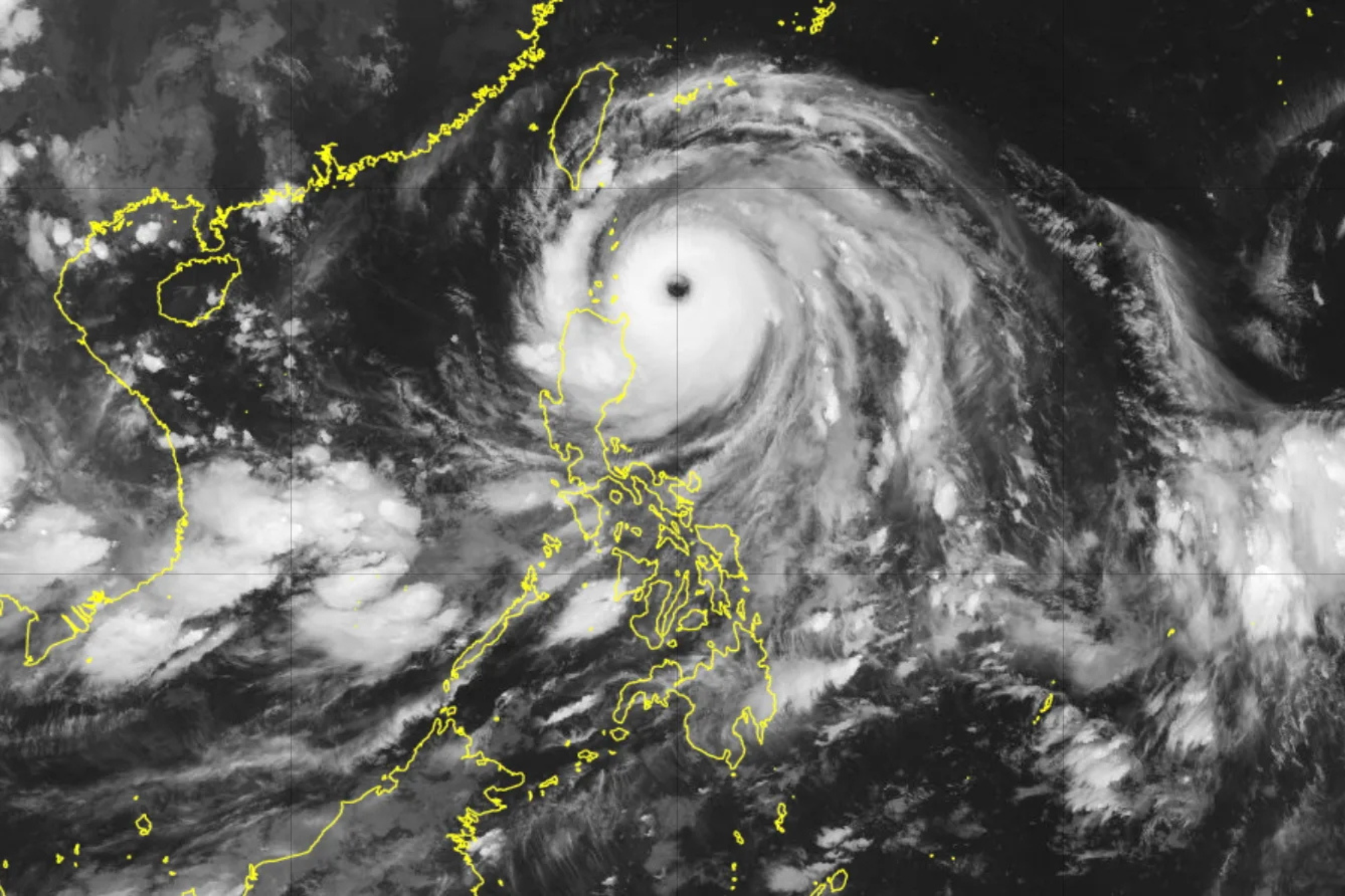
Super Typhoon Nando (international name Ragasa) has steadily intensified and is now bearing down on the Babuyan Islands, triggering maximum alert levels for many northern Luzon communities.
The Philippine Atmospheric, Geophysical and Astronomical Services Administration (PAGASA) has issued Signal No. 5, the highest wind warning, for the northern portion of Babuyan Islands.
As of early Monday morning (4 a.m.), the storm’s center was located about 245 kilometers east of Calayan, Cagayan, moving west-northwest at roughly 20 km/h. Near the center, Nando’s sustained winds are estimated at 205 km/h, with gusts reaching up to 250 km/h.
Because of its trajectory and power, several Tropical Cyclone Wind Signals have been hoisted across different areas:
- Signal No. 5 for the northern Babuyan Islands, including Babuyan, Didicas, Panuitan, and Calayan.
- Signal No. 4 covers southeastern Batanes (areas like Basco, Mahatao, Ivana, Uyugan, Sabtang), the rest of Babuyan, and Santa Ana in Cagayan province.
- Signal No. 3 applies to remaining parts of Batanes, northern and central Cagayan, Apayao, and northern and central Ilocos Norte.
- Signals No. 2 and No. 1 have also been raised for broader areas in Luzon as the effects of Nando spread.
Beyond the wind threat, PAGASA warns of storm surge potentially exceeding 3 meters in low-lying coastal communities in Babuyan, Batanes, Cagayan, as well as parts of Ilocos Norte and Ilocos Sur within the next 24 hours.
The seas are expected to get very dangerous. Waves could reach up to 14 meters along the seaboards of Batanes and Babuyan Islands — making travel by sea highly risky, if not impossible.
Forecasts suggest that Nando may either hit or closely pass over the Babuyan Islands around noon to early afternoon Monday. Afterward, it’s projected to gradually weaken, especially after it interacts with Taiwan’s terrain and moves away.
Authorities are urging people in vulnerable or high-risk areas — particularly coastal and low-lying zones — to prepare for evacuation. Residents are also being advised to stay tuned to updates, secure property, and avoid unnecessary travel, especially over water.
AD
Latest posts

Cebu Hit-and-Run Driver Secures Bail, Remains Under Hospital Arrest

Driver tests negative for alcohol in Banilad hit-and-run that killed young entrepreneur; CCCI calls for road safety reforms

PH Rolls Out Satellite-to-Phone Connectivity With Globe, Starlink

Baricuatro Rejects Claims Linking Her to Enad Suspension
Current show
Upcoming shows


