chevron_left
-
 play_arrow
105.1 TMC 105.1 TMC
-
 play_arrow
Cebu Calling Podcast Kuya Magik

The Philippine Atmospheric, Geophysical and Astronomical Services Administration (Pagasa) announced that it is closely monitoring a tropical depression that is expected to enter the Philippine Area of Responsibility (PAR) within the next few days and could strengthen into a typhoon.
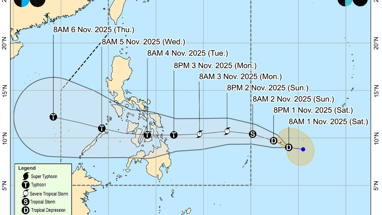
According to Pagasa Weather Specialist Joseph Merlas, as of 10 a.m. on Saturday, November 1, 2025, the tropical depression was located 1,375 kilometers northeast of Mindanao, moving west-northwestward at 15 kilometers per hour.
Merlas clarified that since the weather disturbance remains outside PAR, “it has no direct effect yet over the Visayas area.”
“For today, Saturday, November 1, and even tomorrow, Sunday, November 2, we will still experience generally fair weather just like the warm and sunny conditions we have right now,” he said.
However, Merlas noted that localized thunderstorms may occur over Bohol and southern Cebu, bringing short but isolated rain showers lasting up to one or two hours.
By Sunday, November 2, Pagasa expects the system to enter the PAR, where it will be assigned the local name “Tino.” It will be the 20th tropical cyclone to enter the Philippines this year.
“Once it enters our PAR, it is expected to move westward and possibly make its first landfall over the Caraga Region or Eastern Visayas by Monday evening, November 3, or Tuesday morning, November 4,” Merlas said.
After landfall, forecasts show the storm could traverse parts of Central Visayas, moving across Negros Island and Western Visayas before exiting toward Palawan later in the week.
Merlas identified Tuesday, November 4, and Wednesday, November 5, as the critical period for Central Visayas, when strong winds and heavy rains are likely.
Pagasa said it may raise Tropical Cyclone Wind Signal No. 1 over portions of Eastern Visayas and Caraga by Sunday morning or afternoon, depending on the system’s movement and speed.
Merlas urged residents not to underestimate the tropical depression, stressing that it could intensify into a typhoon once inside PAR.
“This may reach typhoon category with winds of about 120 to 130 kilometers per hour, so we urge everyone to monitor updates and take precautionary measures,” he said.
He also appealed to communities in flood-prone and landslide-prone areas to begin preparations early.
“We know that many are busy observing All Saints’ Day and All Souls’ Day, but we also encourage everyone to take time to prepare for this storm,” Merlas reminded.
Residents are advised to reinforce their homes, trim nearby trees, and secure loose objects that may be blown away by strong winds.
“As this storm moves closer, we may also experience intense rainfall and possible storm surges along coastal areas,” Merlas warned.
He added, “The strongest winds and heaviest rains are usually near the center or eyewall of the typhoon, so we should remain alert once it enters our area.”
Pagasa will continue to issue regular tropical cyclone bulletins and weather advisories as the system approaches the country, urging the public to stay tuned for updates through official government channels.
AD
Written by: topsmediacenter
Rate it
Latest posts


Cebu Hit-and-Run Driver Secures Bail, Remains Under Hospital Arrest

Driver tests negative for alcohol in Banilad hit-and-run that killed young entrepreneur; CCCI calls for road safety reforms

PH Rolls Out Satellite-to-Phone Connectivity With Globe, Starlink

Baricuatro Rejects Claims Linking Her to Enad Suspension
Current show
Upcoming shows

TMC Local Flavours
2:00 pm - 7:00 pm

Stellar Spark Show
7:00 pm - 8:00 pm

TMC Local Flavours
8:00 pm - 10:00 pm

TMC Local Flavours
6:00 am - 8:00 am

Top Of The Morning
8:00 am - 9:30 am
All rights reserved - Copyright 2025 - Tops Media Center


